
What Does a Tornado Look Like on Radar?
Radar usually can't see the tornado itself. Forecasters look for a hook echo on reflectivity, a tight couplet of bright green (toward) and bright red (away) winds on velocity, and, once a tornado is lofting debris, a spot of low correlation coefficient right on that couplet, called a tornado debris signature.
A tornado is a few hundred yards wide. A radar beam 60 miles out is more than a mile wide. So we don't hunt for the tornado. We hunt for its fingerprints. Here are the ones forecasters trust, and the ones that fool people.
Key Takeaways
- A hook echo is a strong clue but not proof of a tornado.
- A velocity couplet is bright green and bright red side by side, showing rotation.
- A TVS is an automated flag for an intense, deep, gate-to-gate couplet.
- Low correlation coefficient on top of a strong couplet means debris in the air.
- Beam height, beam width and scan time limit what radar can catch.
Radar cannot see a tornado directly in most cases. A typical tornado is a few hundred yards wide, while a radar beam at 60 miles from the radar is more than a mile wide and thousands of feet above the ground. Instead, forecasters look for the storm structures and wind patterns that accompany tornadoes, and, once a tornado is on the ground, for the debris it throws into the air. Combining several signatures gives the confidence needed to issue a tornado warning.
Reflectivity Clues
The Hook Echo

A Hook Echo is a curl of precipitation on the rear (usually southwest) flank of a supercell. It forms when the Rear-Flank Downdraft wraps rain and hail around the mesocyclone. The first documented hook echo associated with a tornado was observed near Champaign, Illinois, in April 1953.
Hooks are strong clues but not proof. Many hooks never produce tornadoes, and in high-precipitation supercells or squall lines the hook may be hidden or poorly defined.
The Bounded Weak Echo Region
The updraft of a strong supercell is so intense that precipitation has no time to form inside it. On a vertical slice or at mid-level tilts, this appears as a **Bounded Weak Echo Region (BWER)**: a hole of weak reflectivity surrounded on the sides and top by strong echoes. A BWER, sometimes called a vault, marks a very strong, rotating updraft and a storm capable of large hail and tornadoes.
Related features include a weak echo region (weak echoes under an overhang of strong echoes aloft) and an inflow notch where warm air enters the storm.
Velocity Clues
Doppler radar measures only the part of the wind moving directly toward or away from the radar, called radial velocity. By convention, green colors are toward the radar and red colors are away.
The Velocity Couplet
When a rotating circulation sits within the beam, one side is moving toward the radar and the other side away. This creates a Velocity Couplet: bright green and bright red pixels side by side, with the line between them roughly perpendicular to the radar beam.
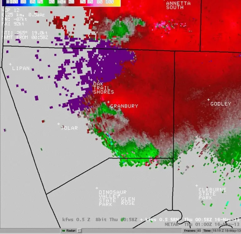
Forecasters judge couplets by:
- Rotational velocity: roughly half the difference between the strongest inbound and outbound speeds. Values over about 40 to 50 knots at low levels suggest a strong tornado threat.
- Tightness: the closer together the maximum inbound and outbound pixels, the stronger the rotation.
- Height: rotation in the lowest tilts, closest to the ground, matters most.
Because storms move, forecasters often use storm-relative velocity, which subtracts the storm's motion so rotation stands out more clearly.
The Tornado Vortex Signature
A **Tornado Vortex Signature (TVS)** is an automated radar algorithm flag for an intense, small-scale couplet with strong gate-to-gate shear (the extreme inbound and outbound values in adjacent pixels) that extends through a significant depth of the storm. A TVS strongly suggests a tornado or one about to form, but it is not confirmation.
Debris Signatures
When a tornado lofts debris such as leaves, insulation, wood, and shingles, dual-polarization radar can detect it.
Correlation Coefficient
**Correlation Coefficient (CC)** measures how similar the targets in a radar volume are in shape, size, and orientation. Rain and snow are fairly uniform, so CC is high, usually above 0.95. Debris is a random mix of objects tumbling at all angles, so CC drops sharply, often below 0.8 and sometimes below 0.5.
The Tornado Debris Signature
A **Tornado Debris Signature (TDS)** is a compact area of:
- Low CC, collocated with
- A strong velocity couplet, and usually
- Moderate to high reflectivity, sometimes appearing as a round debris ball at the tip of the hook.
A TDS is strong evidence that a tornado is on the ground and causing damage right now. Taller debris signatures, reaching 10,000 feet or more, generally indicate stronger tornadoes.
Rotation Tools And NROT
To speed up analysis, radar software computes derived products:
- Azimuthal shear measures how quickly radial velocity changes across the beam, highlighting rotation near the ground (0 to 2 km) and at mid-levels (3 to 6 km).
- **NROT (Normalized Rotation)** compares the strength of a circulation with a threshold that accounts for distance from the radar, so values near or above 1 flag significant rotation regardless of range.
- Rotation tracks accumulate the strongest rotation over time, showing a mesocyclone's path.
Why Can't Radar See Every Tornado?
- Beam height: the beam rises with distance because of Earth's curvature. At 100 miles, the lowest tilt may be 10,000 feet above the ground, missing shallow rotation.
- Beam width: distant circulations are smeared across wide beams.
- Update speed: a full volume scan takes several minutes, and tornadoes can form in less.
- Viewing angle: rotation directly along the beam is hard to see.
That is why spotter reports remain vital, and why most tornado warnings are issued on radar trends before any confirmation.
Try It Here
Real-World Example: Reading a Radar-Confirmed Warning
When an NWS tornado warning is labeled radar confirmed, the forecaster often has a tornado debris signature: a compact low-CC spot sitting on the tight red-green couplet at the tip of the hook. In LightningWX you can line those up yourself by switching between reflectivity, storm-relative velocity and CC at the lowest tilt.
Here's the hard truth that comes with it. If radar can see debris, the tornado is already destroying things. That signature is a confirmation, not a heads-up. If you're in the path, you should already be in your shelter. LightningWX is not an official warning source, so follow your local NWS office.
Common Mistakes
- Myth: Any hook echo means a tornado. Fact: Many hooks never produce tornadoes, and in high-precipitation supercells or squall lines the hook may be hidden or poorly defined.
- Myth: Low CC by itself means debris. Fact: The melting layer, large wet hail, birds, insects and weak signal can lower CC too. A true TDS must line up with strong rotation.
- Myth: Red on velocity radar means dangerous weather. Fact: On velocity, red only means motion away from the radar and green means toward it. The tight pairing of bright red and bright green is what signals rotation.
Go Deeper: Rotational Velocity and Range
Rotational velocity is estimated as half the difference between the strongest inbound and outbound velocities across a couplet. Because the beam broadens with range, the same circulation looks weaker and wider far from the radar. Normalized rotation (NROT) compares a circulation's strength with a threshold that accounts for distance, which is why values near or above 1 are meaningful at any range.
Debris detection relies on dual-polarization. Correlation coefficient measures how similar the targets in a radar volume are in shape, size and orientation. Tumbling, irregular debris drives CC down, often below 0.8 and sometimes below 0.5. Debris signatures reaching 10,000 feet or more generally indicate stronger tornadoes, but remember the lowest tilt sits higher above the ground the farther the storm is from the radar.
Check Yourself
No grades, no sign-in. Pick an answer and see how you did. The app keeps score for you and tracks your progress.
1 What forms a hook echo?
Show The Answer
The rear-flank downdraft wrapping precipitation around the mesocyclone The RFD carries rain and hail around the back of the mesocyclone, creating the hook shape.
2 On Doppler velocity, a velocity couplet appears as:
Show The Answer
Adjacent strong inbound and outbound winds Rotation produces bright green toward and bright red away side by side.
3 Why does debris lower correlation coefficient?
Show The Answer
Debris objects vary randomly in shape, size, and orientation CC is high for uniform targets such as rain and low for a jumble of tumbling objects.
4 What does a bounded weak echo region indicate?
Show The Answer
A very strong updraft where precipitation has not formed yet The BWER is a vault of weak echoes carved by an intense, often rotating updraft.
5 A tornado debris signature requires low CC plus:
Show The Answer
A strong velocity couplet at the same location Low CC alone can have other causes; it must coincide with strong rotation to indicate debris.
Questions People Ask
Can radar see a tornado?
Usually not directly. Radar detects the storm's rotation and, once a tornado is on the ground, the debris it throws into the air.
What is a TVS on radar?
A tornado vortex signature is an automated flag for an intense, small couplet with strong gate-to-gate shear through a significant depth. It strongly suggests a tornado but is not confirmation.
What does low CC mean in a storm?
Low correlation coefficient means the targets are a jumble of shapes and sizes. Collocated with a strong velocity couplet, it indicates tornado debris.
Why are most tornado warnings issued before confirmation?
A full volume scan takes several minutes and tornadoes can form faster, so most warnings are issued on radar trends and spotter reports before debris is seen.
Learn More From The Experts
- Severe Weather 101: Tornado Detection NOAA / NSSL
- Tornado Frequently Asked Questions NOAA / NWS Storm Prediction Center
Hook, couplet, debris. Learn to read them, and still let the NWS warning be what sends you to shelter. — Jen
