
Live NEXRAD Radar
Level II data for every U.S. radar, about 15 seconds behind real time, plus the archive back to 1991. Reflectivity, velocity, dual-pol views and storm products, all with buttons named in English: Radar, Wind, Debris, Hail Size.

 About The AuthorAbout The Author: Meet Jen, The Human Lightning RodStorm spotter, lightning photographer, coin dealer and coder. Who builds LightningWX, and why every obsession of…
 Featured NewRare Air and Raw Science Data: What I Am Building NextTwo new LightningWX modules are on my bench: Rare Air, which forecasts strange and overlooked weather…
Live NEXRAD radar from every U.S. site, satellite lightning drawn on top of everything, rotation and tornado debris flagged the moment the radar sees them, and GenAvaM, our own model, telling you where lightning is likely next. Then it explains every bit of it in plain English, because a weather nerd is just a curious person who kept asking “but why?”
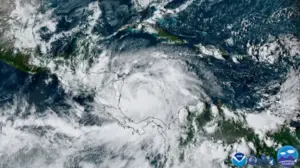
Why This Week: It's the first week of October, and we're still inside Atlantic hurricane season, which runs June 1 through November 30. October storms love to spin up close to home in the Gulf and the western Caribbean, so this is a good week to know how a hurricane is actually built: warm water, moist air, low wind shear and a little spin. Don't be like me and only read up when the cone is already pointed at somebody you love. You learn it now, on a quiet week, and you'll read every advisory better when it counts.
Start The LessonHobbyist, storm spotter, teacher or the person who refreshes radar during every thunderstorm: this one is for you.
Level II data for every U.S. radar, about 15 seconds behind real time, plus the archive back to 1991. Reflectivity, velocity, dual-pol views and storm products, all with buttons named in English: Radar, Wind, Debris, Hail Size.

NOAA GOES satellite lightning and a Lightning Jump alert when a storm’s flash rate suddenly climbs. Lightning never hides under another layer. It earned top billing.

Mesocyclone, strong rotation, tornado vortex signature and tornado debris, each drawn as a ring you can hover for speed, height and distance, with rotation tracks over the last 30 minutes to 2 hours.

Our own model: lightning chance for the next 30 and 60 minutes and a forecast radar out to two hours. It checks itself against real lightning every scan and gets better at your radar over time.

Active NHC storms with the cone, watches and warnings, spaghetti models, intensity guidance and arrival time of tropical-storm winds at your location.

16 units and 61 lessons, college-level ideas in plain language, quizzes, and “Try It in LightningWX” buttons that open the exact tool the lesson is talking about.
Smooth motion glides storms between radar scans, so a loop looks like weather instead of a flip book. This is the real KTLX loop of the May 20, 2013 Moore, Oklahoma tornado.
NEXRAD Level II, about 15 seconds behind real time.
NOAA GOES satellite lightning, never buried under a layer.
Mesocyclones, TVS and debris signatures, tracked scan to scan.
Plain-English meteorology with a Try It button on every lesson.
With your OK at install, LightningWX sends small, scrubbed research packets (how well its forecasts verified, detection counts and crash reports) so GenAvaM learns from every radar site at once. No names, no emails, no coordinates, no license keys. You can read every packet in its outbox before it leaves.
Try everything free for 5 days first. If the subscription ever lapses, LightningWX keeps working as Basic Radar.
Yours to keep. Includes Basic Radar forever.
Subscription. Pick how often you’d like to pay:
5-day free trial of the full product · free account required · saving, exporting, screenshots, recording and streaming need a paid license (not in the trial) · 2-factor sign-in · checks in every 7 days
LightningWX stands on the shoulders of public science: radar, warnings and models from NOAA and the National Weather Service, satellite imagery from NASA and NOAA, and maps from USGS. Meteorological inspiration and credit: Ava C. Flavell.

lightningwx.com uses its own analytics - nothing from Google or Facebook - to see how the site is used. With your OK it also records clicks and scrolling on these pages so I can make them better. Nothing is sold or shared. Privacy Policy
