
What Is the Difference Between a Wall Cloud and a Shelf Cloud?
A wall cloud is a localized lowering beneath a storm's rain-free updraft base, usually near the rear of the storm, and it may rotate and produce a tornado. A shelf cloud is a wedge-shaped cloud on the storm's leading edge, pushed along by outflow. It signals strong winds and heavy rain, not rotation.
Radar is amazing, but it cannot see the bottom of a storm far away, and it cannot tell scary-looking scud from a rotating wall cloud. That is where spotters come in. I am a SKYWARN spotter, and the first thing training teaches is humility: most scary clouds are not tornadoes. Here is how to tell them apart and report what you see.
Key Takeaways
- SKYWARN is the NWS volunteer spotter program, with free training from local offices.
- Report what you saw, where, and exactly when.
- A dangerous wall cloud shows persistent rotation and rapid rising motion.
- Shelf clouds mark the gust front; scud and mammatus are common look-alikes that do not produce tornadoes.
- Report hail with a measured size or a standard comparison, never "marble size."
Radar is powerful, but it cannot see everything. The beam passes over the lowest part of storms at long distances, and it cannot tell a rotating wall cloud from a harmless ragged cloud. That is why the National Weather Service relies on trained volunteers to report what is really happening on the ground. Their eyes turn radar suspicions into confirmed, life-saving information.
What Is a SKYWARN Storm Spotter?
SKYWARN is the NWS volunteer storm spotter program, with several hundred thousand trained spotters across the country. Spotters include emergency managers, firefighters, police, amateur radio operators and ordinary residents.
Local NWS offices offer free training, often in spring and increasingly online. A basic course covers:
- How thunderstorms form and what makes them severe.
- Identifying key storm features and common look-alikes.
- What to report and how.
- Staying safe while observing.
Spotters observe from home or a safe fixed position. Storm spotting is not the same as storm chasing, and it never requires getting close.
What Should Storm Spotters Report to the NWS?
The NWS wants reports of events that meet or approach warning criteria or cause impacts:
- Tornadoes, funnel clouds and rotating wall clouds, with location and direction of motion.
- Hail of any size, especially 1 inch (quarter size) or larger. Compare to coins or balls, or better, measure with a ruler. Avoid vague terms like "marble size."
- Wind gusts of 58 mph or more, measured or estimated, and wind damage such as trees or power lines down.
- Flooding: water over roads, flooded homes, rapidly rising streams.
- Heavy rain totals and heavy snow amounts.
- Damage of any kind, and any injuries or deaths.
Always include what you saw, where (your location and the direction and distance to the event), and when (the exact time). An accurate time makes a report far more useful.
How Do You Identify a Wall Cloud, Shelf Cloud and Scud?
Rain-Free Base
In a supercell, the updraft area is often a flat, dark cloud base with little or no precipitation falling from it. This Rain-Free Base usually sits on the storm's southern or southwestern flank (for storms moving northeast), next to the heavy precipitation core. It is where a wall cloud, and possibly a tornado, will form.
Inflow
Warm, moist air flowing into the updraft often shows up as inflow bands (low bands of cloud feeding into the storm) or a strong wind blowing toward the storm. A sudden increase in inflow can signal intensification.
Wall Cloud
A Wall Cloud is a localized, persistent lowering of the rain-free base, often a few hundred meters to a few kilometers wide. It forms where the updraft draws in very moist, rain-cooled air that condenses at a lower level.
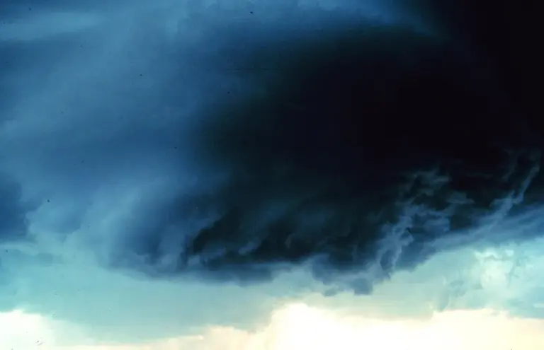
Signs of a dangerous wall cloud:
- Persistent rotation around a vertical axis.
- Rapid vertical motion, with cloud fragments rising into it.
- Location near the rear of the storm, beside the precipitation core.
- Persistence for 10 to 20 minutes or more.
Many wall clouds never produce tornadoes, but most strong tornadoes come from them.
Scud: The Common Look-Alike
Scud are ragged, low cloud fragments that often form beneath storms or along gust fronts. They can look alarming, even hanging down like a funnel, but they are usually drifting with the wind or rising randomly, not rotating. Most false tornado reports come from scud. Watch for organized, persistent rotation before reporting.
Shelf Cloud
A Shelf Cloud is a low, wedge-shaped cloud attached to the leading edge of a thunderstorm's outflow, the gust front. It forms where cool outflow air lifts warm, moist air ahead of the storm.
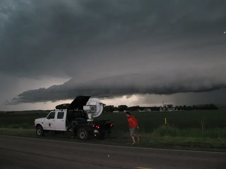
Shelf clouds are often striking, with layered, terraced structures. They signal strong outflow winds and possibly damaging gusts, followed by heavy rain. Shelf clouds sit on the leading edge of the storm, ahead of the rain, and are pushed along by outflow, while wall clouds hang beneath the updraft near the rear of the storm. Confusing the two is common.
Mammatus
Mammatus are pouch-like clouds hanging from the underside of a thunderstorm anvil. They form where cold, cloudy air sinks into drier air below.
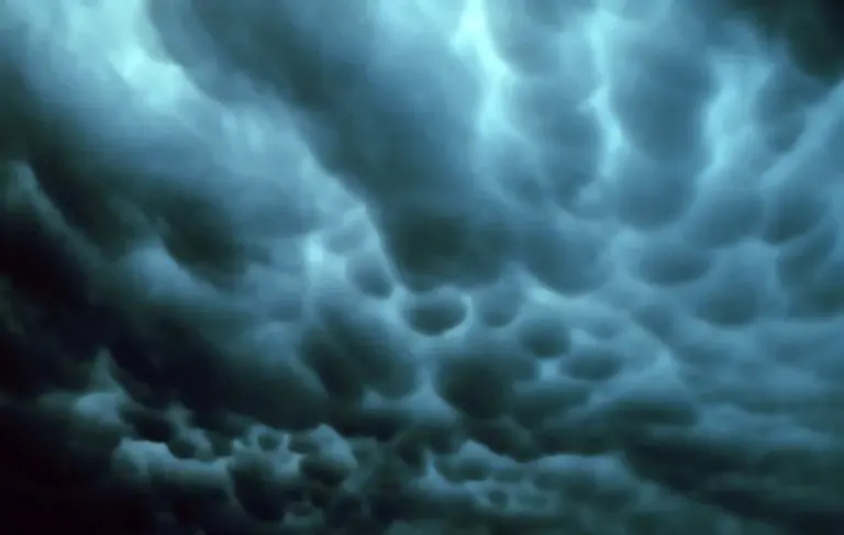
They can look ominous, but mammatus are harmless in themselves. They often appear after a strong storm has passed or on the edges of the anvil. Their presence can indicate a strong storm nearby, but they do not produce tornadoes.
How Do You Report Severe Weather to the National Weather Service?
- Call your local NWS office using the spotter number provided in training, or report through local emergency management.
- Amateur radio SKYWARN nets relay reports directly to the NWS during severe weather.
- mPING (Meteorological Phenomena Identification Near the Ground) is a free smartphone app from NOAA's National Severe Storms Laboratory. Anyone can report precipitation type, hail size, wind damage and flooding. The reports help researchers and forecasters, especially during winter storms.
- Social media reports tagged with location and time also reach many NWS offices.
Local Storm Reports
The NWS collects verified reports and issues them as a Local Storm Report (LSR). SPC compiles them nationally into daily storm report maps of tornadoes, hail and wind. These reports:
- Confirm warnings and help forecasters decide to extend or upgrade them.
- Verify forecasts and warnings after the event.
- Build the climate record of severe weather.
Try It Here
Real-World Example: A Good Report Versus a Vague One
Compare two reports. One says: "Big hail, scary cloud, near town." The other says: "Hail 1.25 inches measured with a ruler, 3 miles east of the courthouse, 4:42 p.m. Ragged cloud below the base, not rotating." The second one gives the NWS a size that meets warning criteria, a location, an exact time, and an honest read on the cloud. That is the kind of report that can confirm a warning or help forecasters extend it. It also shows up later in the SPC storm reports, where it becomes part of the climate record.
Common Mistakes
- Myth: Any cloud hanging down below a storm is a funnel. Fact: Ragged scud often hangs down but drifts or rises randomly. Watch for organized, persistent rotation before reporting a funnel.
- Myth: Shelf clouds and wall clouds are the same thing. Fact: Shelf clouds sit on the leading edge of the storm's outflow. Wall clouds hang beneath the updraft near the rear of the storm.
- Myth: Mammatus clouds mean a tornado is coming. Fact: Mammatus are harmless pouches under an anvil. They can mean a strong storm is nearby, but they do not produce tornadoes.
- Myth: Spotting means chasing storms up close. Fact: Spotters observe from home or a safe fixed position. Spotting never requires getting close, and no report is worth your life.
Go Deeper: Why Wall Clouds Form Under the Updraft
A supercell's updraft ingests air from more than one source. Some of it is warm, moist inflow from ahead of the storm. Some is rain-cooled air from the forward flank that is already near saturation. That more humid air condenses at a lower height than the surrounding inflow, so the cloud base drops in one spot beneath the strongest updraft. That localized lowering is the wall cloud, and when the updraft is rotating as part of a mesocyclone, the wall cloud rotates with it.
Shelf clouds come from the opposite process. Cool, dense outflow spreads out along the ground as a gust front, and warm air ahead is forced up its sloping edge. The rising air condenses into a wedge or layered shelf. Because one is tied to the updraft and the other to the outflow, location relative to the rain core is the spotter's best clue.
Check Yourself
No grades, no sign-in. Pick an answer and see how you did. The app keeps score for you and tracks your progress.
1 What is the key sign of a potentially dangerous wall cloud?
Show The Answer
Persistent rotation with rapid rising motion Persistent, organized rotation and strong upward motion suggest a wall cloud capable of producing a tornado.
2 Scud clouds are often mistaken for what?
Show The Answer
Funnel clouds or tornadoes Ragged scud can hang down like a funnel, but it usually lacks organized rotation.
3 What does a shelf cloud mark?
Show The Answer
The leading edge of the storm's outflow or gust front Shelf clouds form along the gust front, and damaging winds often follow.
4 Are mammatus clouds dangerous by themselves?
Show The Answer
No, they are harmless pouches under an anvil Mammatus can indicate a strong storm nearby, but they do not themselves produce severe weather.
5 Which is the most useful way to report hail size?
Show The Answer
The measured diameter or a comparison to a common coin or ball Precise measurements or standard comparisons like quarter size (1 inch) help forecasters verify warnings.
Questions People Ask
How do you become a SKYWARN storm spotter?
Take a free SKYWARN class from your local NWS office, often offered in spring and increasingly online. The class covers storm structure, identifying features, what to report and how to stay safe.
What size hail should be reported?
Report hail of any size, especially 1 inch (quarter size) or larger. Measure with a ruler if you can, or compare to a coin or ball.
Are shelf clouds dangerous?
A shelf cloud marks the storm's gust front, and strong, possibly damaging winds and heavy rain often follow. It is not a sign of rotation.
What is mPING?
mPING is a free smartphone app from NOAA's National Severe Storms Laboratory. Anyone can use it to report precipitation type, hail, wind damage and flooding.
What should a storm report include?
Include what you saw, where (your location and the direction and distance to the event), and exactly when.
Learn More From The Experts
- SKYWARN Storm Spotter Program NOAA / NWS
- Severe Weather 101 NOAA NSSL
- SPC Storm Reports NOAA SPC
Most scary clouds are scud. Report the honest version, from a safe spot, with the exact time. Jen — Jen
