
How Do Hurricanes Form?
Hurricanes form over ocean water of about 80 F (26.5 C) or warmer. A tropical wave or other disturbance gathers thunderstorms, low wind shear lets them stack up, and the Coriolis effect adds spin. Warm, moist air rises, releases heat, lowers pressure and strengthens winds. At 74 mph sustained winds, it is a hurricane.
I live on Florida's Space Coast, so from June through November I watch the tropics the way other people watch their phones. A hurricane is not random chaos. It is a heat engine with a recipe, and once you know the recipe you can read the forecasts like a pro. Let's build one from scratch, on paper, where it can't hurt anybody.
Key Takeaways
- Hurricanes need ocean water of about 26.5 C (80 F) through a depth of roughly 50 meters.
- Low vertical wind shear lets the warm core stack up instead of being torn apart.
- Most Atlantic hurricanes start as tropical waves rolling off Africa.
- A tropical storm has winds of 39 to 73 mph; a hurricane has 74 mph or more.
- Weakening winds do not mean safety, because much of the danger comes from water.
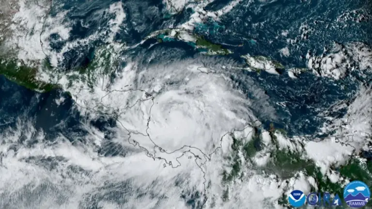
A hurricane is a heat engine. It takes energy from warm ocean water, turns it into rising air and released latent heat, and spends that energy as wind. In the Atlantic and eastern Pacific we call the strongest of these storms hurricanes; in the western Pacific they are typhoons, and in the Indian Ocean and South Pacific they are cyclones. All are the same thing: a Tropical Cyclone, a warm-core, non-frontal low-pressure system organized around a closed circulation.
What Conditions Are Needed for a Hurricane to Form?
Tropical cyclones need a specific recipe. Missing any one ingredient usually stops development.
- Warm ocean water. Sea Surface Temperature of at least about 26.5 C (80 F), through a depth of roughly 50 meters, so that storm-churned water does not quickly cool the surface.
- Moist mid-levels. Dry air in the middle troposphere gets pulled into thunderstorms, creates downdrafts and chokes development.
- **Low vertical Wind Shear.** If winds change a lot in speed or direction with height, the storm's top gets blown away from its bottom and the warm core cannot stack up. Shear below about 10 m/s (20 knots) is generally favorable.
- Enough spin. Formation needs the Coriolis Effect, which is why tropical cyclones almost never form within about 5 degrees of the equator.
- A pre-existing disturbance. Storms do not form from nothing; they need a trigger.
- An unstable atmosphere that supports deep thunderstorms.
Where Do Most Atlantic Hurricanes Start?
In the Atlantic, most hurricanes begin as a Tropical Wave (sometimes called an easterly wave), a kink in the trade-wind flow that rolls off Africa about every three to four days during summer. Only a small fraction of these waves develop, but the ones that do produce the long-track Cape Verde hurricanes. Other seeds include old fronts that stall over warm water, monsoon troughs, and upper-level lows that work down to the surface.
From Cluster To Hurricane
- Organization. Thunderstorms cluster around the disturbance. As they release latent heat, surface pressure starts to fall.
- A closed circulation. Air spirals inward at the surface. Once winds complete a closed loop around a defined center, forecasters can classify a tropical cyclone.
- The feedback loop. Stronger winds pull more heat and moisture from the sea surface, which fuels more thunderstorms, which lowers pressure further, which strengthens the winds. This air-sea feedback is what lets hurricanes intensify.
- Outflow. At the top of the storm, air spreads outward in a clockwise anticyclone (in the Northern Hemisphere). Good outflow acts like an exhaust fan.
What Is the Difference Between a Tropical Storm and a Hurricane?
Classification is based on maximum sustained winds (a 1-minute average in the US system, at 10 meters height):
- Tropical Depression: closed circulation, winds up to 38 mph. Given a number.
- Tropical Storm: winds 39 to 73 mph. Given a name.
- Hurricane: winds 74 mph or higher.
- Major Hurricane: Category 3 or higher, 111 mph or more.
What Are the Parts of a Hurricane?
The Eye
The eye is the calm center, typically 20 to 40 miles across. Air sinks there and warms by compression, clearing skies and making the eye the warmest part of the storm. Winds are light, and the lowest pressure is found here.
The Eyewall
The Eyewall is a ring of towering thunderstorms around the eye with the strongest winds and heaviest rain. Intense storms sometimes go through an eyewall replacement cycle: a new outer eyewall forms, chokes off the inner one, and the storm temporarily weakens while its wind field expands.
Rainbands
Spiral rainbands curve inward toward the center. They bring bursts of heavy rain, gusty winds and sometimes tornadoes, separated by lulls.
What Makes a Hurricane Weaken?
Hurricanes weaken when they move over land (losing their heat and moisture supply and gaining friction), over cooler water, into high shear, or into dry air. Many transform into extratropical cyclones at higher latitudes, gaining fronts and a cold core while sometimes keeping hurricane-force winds.
Real-World Example: Reading The Tropical Weather Outlook
Every day in hurricane season the National Hurricane Center publishes a Tropical Weather Outlook. It marks areas of disturbed weather and gives each one a chance of formation over the next 2 and 7 days. When a wave comes off Africa, you will often see a low chance at first. As thunderstorms organize and a closed circulation shows up, those numbers climb.
The Tropical Cyclone Discussion is where forecasters explain why. You will see the same ingredients from this lesson: sea surface temperature, shear, dry air. Once you know the recipe, those discussions stop reading like a foreign language. In LightningWX you can open these NHC products in the Text window, but the official source is always the NHC and your local NWS office.
Common Mistakes
- Myth: Hurricanes, typhoons and cyclones are different kinds of storms. Fact: They are the same thing, a tropical cyclone. The name depends only on which ocean basin it forms in.
- Myth: Hurricanes can form right on the equator where the water is warmest. Fact: They almost never form within about 5 degrees of the equator, because the Coriolis effect is too weak there to start the spin.
- Myth: The eye is the most dangerous part of the storm. Fact: The eye is calm with sinking air. The eyewall around it has the strongest winds and heaviest rain, and it returns from the other direction after the eye passes.
- Myth: Once a hurricane weakens over land, the danger is over. Fact: Weakening storms can still drop feet of rain far inland. Much of the loss of life in tropical cyclones comes from water, not wind.
Go Deeper: The Air-Sea Heat Engine
A mature hurricane can be modeled as a heat engine. Air spirals inward near the sea surface, picking up heat and moisture from the warm ocean. It rises in the eyewall, where water vapor condenses and releases latent heat, then flows out at high altitude, near the tropopause, where it is far colder. The temperature difference between the warm ocean and the cold outflow layer sets an upper limit on how strong the storm can get, often called its potential intensity.
This is why ocean heat content matters, not just surface temperature. A storm's own winds mix the upper ocean and bring up cooler water from below. If warm water is shallow, the storm cools its own fuel supply. Deep warm water, such as warm eddies in the Gulf of Mexico, removes that brake. Vertical wind shear works against the engine by tilting the vortex and ventilating the core with drier, lower-energy air.
Check Yourself
No grades, no sign-in. Pick an answer and see how you did. The app keeps score for you and tracks your progress.
1 What minimum sea surface temperature is usually needed for tropical cyclone formation?
Show The Answer
About 26.5 C Roughly 26.5 C (80 F) water, through a decent depth, is the classic threshold.
2 What maximum sustained winds make a tropical storm a hurricane?
Show The Answer
74 mph Hurricanes have sustained winds of 74 mph or more. Tropical storms are 39 to 73 mph.
3 Why does strong vertical wind shear hurt a developing hurricane?
Show The Answer
It tilts the storm and blows the heat and moisture away from the center Shear displaces the upper warm core from the surface circulation and disrupts organization.
4 Why is the eye of a hurricane usually clear?
Show The Answer
Air sinks in the eye and warms, drying it out Subsidence warms and dries the air in the eye, suppressing clouds.
Questions People Ask
What water temperature does a hurricane need?
About 26.5 C (80 F) or warmer, through a depth of roughly 50 meters. That depth keeps storm-churned water from quickly cooling the surface.
Why is the eye of a hurricane calm and clear?
Air sinks in the eye and warms as it is compressed, which dries it out and clears the clouds. Winds there are light, and the lowest pressure is found in the eye.
When does a tropical storm get a name?
A tropical depression gets a number. Once sustained winds reach 39 mph it becomes a tropical storm and gets a name.
When is hurricane season?
The Atlantic hurricane season officially runs from June 1 to November 30, with most activity from August through October.
What is a Potential Tropical Cyclone?
It is a disturbance that has not formed yet but is expected to bring tropical storm or hurricane conditions to land within 48 hours, so the NHC can issue advisories and warnings early.
Learn More From The Experts
- NOAA JetStream: Tropical Cyclone Introduction NOAA / NWS
- NOAA JetStream: Tropical Cyclone Structure NOAA / NWS
- Tropical Cyclone Climatology National Hurricane Center
Know the recipe, watch the outlook, and let the NHC do the worrying first. Jen — Jen
